3D Star Mapping software for gamers, authors, and space buffs!
AstroSynthesis 3.0 - Comprehensive Feature List
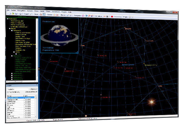
3D Coordinates!Map stars, black holes, space stations, and other stellar bodies in 3D space. Zoom in, out, rotate, and pan around your star map. See what stars look like from different vantage points.
Star System Generator
Generate planet-loads of detailed system information for thousands of star systems. The built-in star system generator creates detailed information about stars, their planets, moons, planetoids, and other objects in space! The star system generator isn't just a randomizer. It applies scientific principles during generation, taking into consideration matters of astronomy, physics, atmospheric chemistry, and planetary sciences during the generation process.
Not Just Stars!
Place other types of interstellar bodies on your sector map - black holes, white dwarfs, free objects, nebula, fleets, and others.
Animated Orbital Display
Exciting animated display of planet orbits around stars, and moons around planets. Move forward or backward in time at selected rates and watch as the planets move around their parent star according to Keplerian rules of planetary motion.
Planet Maps
Need a planet map? Automatically generate surface maps of any terrestrial planet! You can even edit the maps using Fractal World Explorer v1.6 (included for free with AstroSynthesis), and convert them into Fractal Mapper maps. AstroSynthesis can create great Gas Giant atmosphere images as well! And if you would rather assign your own planet map... You can do that too!
Fractal Terrains integration
If you own ProFantasy's Fractal Terrains, you can choose to use that as the default planet generating engine. AstroSynthesis can call the FT engine to let you generate and edit planetary surface maps! From there you can export your surface maps for use in ProFantasy's Campaign Cartographer!
(note: requires a version of Fractal Terrains from October 2004 or later).
3D Models
Ships, Fleets, Space Stations, and other bodies are displayed as 3D models. You can pan and rotate around them, and zoom closer for a better look at any angle! And its easy to add your own 3D models. (several formats supported)
Blazon Images
You can assign images for uses as blazon images on the 3D map to identify political affiliations.
Stellar Routes
Display stellar routes between systems. Routes automatically show the distance of each route segment. You can even let the program generate hundreds or thousands of star routes automatically based on your criteria.
Large Star Maps
AstroSynthesis can easily track detailed system information for hundreds of thousands of stars! Under Windows XP, AstroSynthesis can handle sector map files greater than 4GB in size!
Scripting Interface
Create plug-ins using VBScript to enhance and extend the program's capabilities! Add features to the program menus, create your own windows, even create your own star system generators! AstroSynthesis' data files are also a common database format, and easily readable with most programming languages.
Animations
See incredible animation sequences as the program brings you on a tour of your star sector. You can even save them as movie files that others can watch!
Subsectors
Define sub-regions in your sector map to easily identify regions.
Display Filters
AstroSynthesis features powerful filtering options to let you toggle the display of stars based on population, habitability, political affiliation, and subsector. You can also filter routes to control their display based on their type.
Grids
Frame your star sector or subsector within a box or spherical grid, in any color you select.
Spheres of Influence
Place semi-transparent, 3D cube or spheres around stars to show areas of influence or other travel information.
Interplanetary Travel Calculator
Use the Travel Calculator to calculate travel times between planets in a star system, or between moons around a planet. Calculate travel times based on a given acceleration or velocity. Show travel times at specific dates, or for nearest and farthest approaches.
Search
With all those stars on your map, you'll love the Search feature that lets you look for specific stars and planets! Search for planets with populations, or objects of a certain type. Or you can search for bodies with a certain name. Or you can combine the criteria for more detailed searches.
Customizable Data
AstroSynthesis tracks a lot of data. But that doesn't mean you can't track your own data fields! You can customize your map to track your own data fields with each body on your map. This way you can customize your map to your specific campaign or sci-fi universe!
Notes
Store your notes about specific systems, stars, and planets right in your map! There's even a special place for the GM's notes.
Sector Report
AstroSynthesis can generate a hyperlinked HTML based report that shows all the details for each star system, as well as any surface maps assigned to planets.
Image Export
Export your map to a 2D friendly graphic file, or capture an image of the current 3D view. You can export files as Windows bitmaps (.bmp), JPEG's (.jpg), Portable Network Graphics (.png), or Windows Metafiles (.emf)
Printing
Print a 2D friendly map of your 3D star sector. You can print across multiple pages to create great poster sized maps! You can even print or export specific sections of your map. The handy print preview feature lets you see how your multi-page prints will tile together.
Real Universe Data
Included is a sample map containing all stars within 20 ly of Sol. Other data sets (100 ly, 500 ly, 1000 ly, etc) are available as downloads from our web site!
Data Import
Great for experienced star mappers! Import .csv data files created from other stellar database. Or use the .xml import to bring in data stored in AstroSynthesis' XML format.
Fractal Mapper Integration
If you're one of the thousands using our flagship campaign mapping program, Fractal Mapper, you'll be happy to know you can export surface maps of planets generated within AstroSynthesis to FM's format. In FM you can add in your city markers, national boundaries, roads, rivers... whatever you'd like!
 Instant Download