Log in to your NBOS account to upload files
| Recent Uploads | |
|---|---|
| Jörðgarð Map No. 517 - Alderli | 02/28/2025 |
| Jörðgarð Map No. 516 - Elven Cottage in the Wood | 02/07/2025 |
| Jörðgarð Map No. 515 - Settlement Ruin | 01/20/2025 |
| Jörðgarð Map No. 514 Fork in the Trail | 01/17/2025 |
| Jörðgarð Map No. 513a - Riddle Bridge | 01/17/2025 |
| Most Downloaded | |
|---|---|
| NBOS Character Sheet Designer v2.0 | 129521 |
| Inspiration Pad Pro 3.0 | 24035 |
| Inspiration Pad Pro 2.0 | 18297 |
| Fractal Mapper 8 PDF | 13222 |
| ScreenMonkey Lite 1.8k | 9786 |
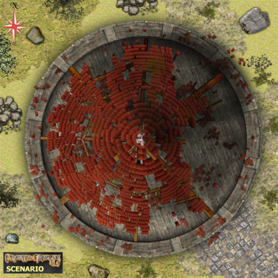
Jörðgarð Map of Week #280 -Island Tower Ruin
Contributor:
MarkOliva
Rating:
Date Added:
11/13/2016
Downloads:
1215
Description:
The 280th Map of the Week is from the second Jörðgarð (TM) Trails adventure on the Fallen Empire Trail, "Draug Hunters." The map shows a tower ruin that stands on a small islet just offshore from the island of the Æsir warror Skíði and his wife, the ranger Reyndí, in the Misty Spring lake area. Misty Spring is a large lake that is fed by a spring. The lake is the source of the Fogwater River. Unknown to most, there are several populated islands upon the lake. It is a hidden area, constantly covered by a magical fog.
The dwellers of the Misty Spring area know nothing about the history or earlier uses of the tower, and it no longer offers clues as to its purpose. The stone walls of the tower, 50 feet/15 meters high, still are intact, but the wooden stairway and floors inside have rotted away. Little is left of them. The lattice work that holds the roof tiles also is badly rotted. Tiles fall frequently to the ground floor or the surrounding grassland, posing a serious danger for the curious. Except when the water is particularly high, one usually can walk dry from the main isle to the islet, but there are quicksand pits. Even when the water is high, one can walk through the water to the islet, but then there is not only the danger of quicksand but also of poisonous water snakes.
You can get this map in two versions:
1. The Fractal Mapper (TM) 8 version in FMP format, fully editable (15 MB) from the Jörðgarð website.
2. As a JPG flat map of 1360 x 1360 Pixels (700 KB), available with the hyperlink below.
Both versions are released for personal and commercial use under the Open Game License Version 1.0a, which you can read on the Jörðgarð website at:
www.vintyri.org/joerdhgardh/
Next Week: Bjarni and Ölveig's Island
Mark Oliva
The Vintyri (TM) Project
www.vintyri.org
info@vintyri.org