Log in to your NBOS account to upload files
| Recent Uploads | |
|---|---|
| Jörðgarð Map No. 517 - Alderli | 02/28/2025 |
| Jörðgarð Map No. 516 - Elven Cottage in the Wood | 02/07/2025 |
| Jörðgarð Map No. 515 - Settlement Ruin | 01/20/2025 |
| Jörðgarð Map No. 514 Fork in the Trail | 01/17/2025 |
| Jörðgarð Map No. 513a - Riddle Bridge | 01/17/2025 |
| Most Downloaded | |
|---|---|
| NBOS Character Sheet Designer v2.0 | 129521 |
| Inspiration Pad Pro 3.0 | 24035 |
| Inspiration Pad Pro 2.0 | 18297 |
| Fractal Mapper 8 PDF | 13222 |
| ScreenMonkey Lite 1.8k | 9786 |
Jörðgarð Map of Week #253 - Greipur's Lair
Contributor:
MarkOliva
Rating:
Date Added:
05/08/2016
Downloads:
1397
Description:
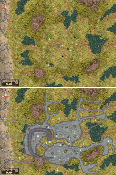
The 253rd Map of the Week is from the second Jörðgarð (TM) Trails adventure on the Fallen Empire Trail, "Draug Hunters." The map shows two views, one of the surface area over the lair of the 1,200-year-old Æsir wizard Greipur and one of the layout of the wizard's subterranean dungeon.
Key to the Overland View:
Areas marked 1 are mining shafts that have broken off with time. On the surface level, the shafts marked No. 1 begin with spiral stairways that are hidden by rubble in the openings. Somewhat lower, the shafts crumbled, and the stairways now end d20 + 30 feet/d6 + 18 meters above the cavern floors. Any PCs who use the lower 10 feet/3 meters of such stairs are liable to cause additional crumbling of the stairs.
Area No. 2 is the magically hidden main entrance to the mine.
Areas marked 3 are small rows of foundation stones that once were the bases of buildings. They have no
significance.
Area No. 4 is what's left of the hoist station that once was used to left ore to the surface where it could be taken to the smelter, a structure that no longer exists. The hoist is gone, but if one clears away the rubble, one will find that the hoist shaft still is intact.
Areas marked 5 are basically the same as the areas marked No. 1, except that these shafts still are intact.
Outer areas:
Locations Numbered 1 – The Soughs.
Locations Numbered 2 – Collapsed Soughs.
Locations Numbered 3 – Abandoned Lodes.
Location No. 7 – Moeðing Underground Creek
Location No. 11 - Collapsed Tunnel
Location No. 12 - Entrance on the Surface
Section A - This area is not guarded
Location Number 8 – Mining Shafts
Location No. 13 - End of Entrance Road from Surface.
Section B - Greipur's Domain
Location No. 4 - Lair of Greipur's Orcs
Location No. 5 - Greipur's Fortress
Location No. 6 - Empty Lode
Location No. 8 - Mining Shaft
Locations No. 10 - Connecting Tunnels
Section C - Lead Golem Domain
Location No. 8 - Mining Shaft
Location No. 9 - Elevator Shaft
You can get these maps in two versions:
1. The Fractal Mapper (TM) 8 version in FMP format, fully editable (20 MB) from the Jörðgarð website.
2. As two JPG flat maps of 1360 x 1020 Pixels each (1.2 MB), available with the hyperlink below.
Both versions are released for personal and commercial use under the Open Game License Version 1.0a, which you can read on the Jörðgarð website at:
www.vintyri.org/joerdhgardh/
Next Week: Greipur's Lair - Orc Lair Zoom View
Mark Oliva
The Vintyri (TM) Project
www.vintyri.org
info@vintyri.org