Log in to your NBOS account to upload files
| Recent Uploads | |
|---|---|
| Jörðgarð Map No. 517 - Alderli | 02/28/2025 |
| Jörðgarð Map No. 516 - Elven Cottage in the Wood | 02/07/2025 |
| Jörðgarð Map No. 515 - Settlement Ruin | 01/20/2025 |
| Jörðgarð Map No. 514 Fork in the Trail | 01/17/2025 |
| Jörðgarð Map No. 513a - Riddle Bridge | 01/17/2025 |
| Most Downloaded | |
|---|---|
| NBOS Character Sheet Designer v2.0 | 129521 |
| Inspiration Pad Pro 3.0 | 24035 |
| Inspiration Pad Pro 2.0 | 18297 |
| Fractal Mapper 8 PDF | 13222 |
| ScreenMonkey Lite 1.8k | 9786 |
Jörðgarð Map of Week #185 - Military Closed Camp
Contributor:
MarkOliva
Rating:
Date Added:
12/21/2014
Downloads:
1395
Description:
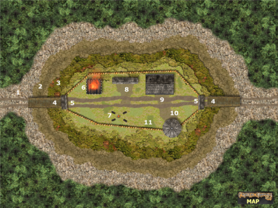
The 185th Map of the Week is our last for 2014. After today, we'll be starting our annual Christmas break, returning with No. 186 on January 11. This week we take a look at a typical military closed camp in Slovania's Border March. The camps provide a guarded campground for travelers on the road from Óðinn's House to Sentinel City in areas where there are no village or hostelries with accomodations.
Key to the Closed Camp Map
1. Cleared Area
2. Moat
3. Raised Flank
4. Drawbridge
5. Gatehouse over the Drawbridge
6. Semaphore. The wooden tower is 60 feet/18 meters high. When the militiamen wish to warn surrounding areas, they light a large fire atop the tower. The fire platform is made of bronze, to prevent the tower from burning.
7. Camping Area. Non-military travelers can lay out their sleeping bags and build their campfires here. Tents are allowed only when the occupancy is low enough that there is room for them.
8. Horse Shed. Reserved for the horses of the militiamen.
9. Detachment House. Reserved for the permanent civilian caretakers and militiamen.
10. Watchtower. The wooden tower is 70 feet/21 meters high.
11. Palisade Wall. The wall is 20 feet/6 meters high.
You can get this map in two versions:
1. The Fractal Mapper (TM) 8 version in FMP format, fully editable (11 MB) from the Jörðgarð website.
2. As a JPG flat map of 1360 Pixels x 1020 Pixels, (500 KB), available with the hyperlink below.
Both versions are released for personal and commercial use under the Open Game License Version 1.0a, which you can read on the Jörðgarð website at:
www.vintyri.org/joerdhgardh/
January 11: Slovania: The Village of Goldfields
Mark Oliva
The Vintyri (TM) Project
www.vintyri.org
info@vintyri.org