Log in to your NBOS account to upload files
| Recent Uploads | |
|---|---|
| Jörðgarð Map No. 517 - Alderli | 02/28/2025 |
| Jörðgarð Map No. 516 - Elven Cottage in the Wood | 02/07/2025 |
| Jörðgarð Map No. 515 - Settlement Ruin | 01/20/2025 |
| Jörðgarð Map No. 514 Fork in the Trail | 01/17/2025 |
| Jörðgarð Map No. 513a - Riddle Bridge | 01/17/2025 |
| Most Downloaded | |
|---|---|
| NBOS Character Sheet Designer v2.0 | 129486 |
| Inspiration Pad Pro 3.0 | 24034 |
| Inspiration Pad Pro 2.0 | 18297 |
| Fractal Mapper 8 PDF | 13222 |
| ScreenMonkey Lite 1.8k | 9786 |
Jörðgarð Map of Week #84 - Dwarven Highway Diggings

Contributor:
MarkOliva
Rating:
Date Added:
11/11/2012
Downloads:
1585
Description:
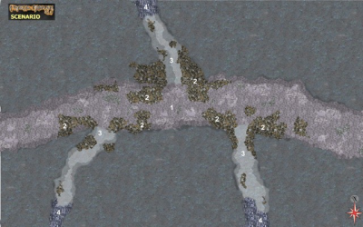
With the 84th Map of the Week we continue in the borderlands town of Óðinn's House in the Kingdom of Slovania. This week we take a look at the Dwarven Highway diggings.
Key to the Dwarven Highway diggings (Highway Location No. 3)
As discussed last week, something has been going on here, something that has even the Northern Circle puzzled. In the ceiling of the highway extension, at about the point where one sees the No. 1 on the scenario plan, is the runic stave Eldrdauðiglötun, just as at locations 2, 7 and 9. It will unleash six balls of fire upon any intruders who pass without password protection. The stave reactivates 10 minutes after being triggered. However, at three points here, somethiung has burrowed into the highway. It is almost certain that it was immune to the fire trap of the runic stave or that it did not set it off at all. Nothing in the area has been charred from a fire blast, and there are no burnt corpses in the area. Furthermore, whatever burrowed into the highway went back whence it came and filled the tunnel it made with loose rock. Members of the Northern Circle dug out the rock fill to a depth of several feet/meters, but finally gave up after finding nothing. What lurks deeper inside the rock is uncertain.
1. Highway extension. The tunnel is roughly 20 feet/6 m wide and 10 feet/3 m high. This also is the point in the ceiling where the runic stave was cut.
2. Tailings. These were left behind by members of the Northern Circle after they attempted to dig the mysterious passages open again.
3. Cleared passages. These are the parts of the passages that were cleared by the Northern Circle.
4. Closed passages. These are the areas that were filled again by the mysterious burrowers. How deep they lead into the bedrock is unknown
You can get the scenario in two versions:
1. The Fractal Mapper (TM) 8 map in FMP format, fully editable, from our Jörðgarð web page (9.1 MB).
2. As a JPG flat map of 1360 Pixels x 850 Pixels (450 KB), available with the hyperlink below.
Both versions are released for personal and commercial use under the Open Game License Version 1.0a, which you can read on the Jörðgarð website at:
www.vintyri.org/joerdhgardh/joerdhgardh.htm
Next week: Óðinn's Fortress - The Dwarven Highway's Flooded Area
Mark Oliva
The Vintyri (TM) Project
www.vintyri.org
info@vintyri.org